6 Favorite Areas for Wildflowers
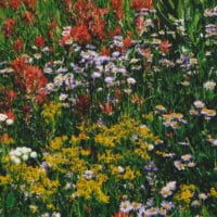
Our area becomes a sea of color from late May until September. The wildflowers arrive to shed a delicate beauty on the world. Nearby, Lassen Volcanic National Park has more than 700 flowering plants. Plumas County supports over 2,000 species of plants, including many rare and gorgeous wildflowers. You could center an entire trip or many trips over different seasons just by looking at wildflowers. Here are a few of our favorite blooms and when to find them. We’ve listed them in order of earliest to latest colors for ease in planning your trip. 2023 should be an excellent year for wildflowers late into the summer and a great year to visit waterfalls in the region.
Wildflowers of Lassen Volcanic Park
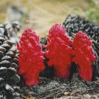
Snow Plant: The bright red plant is a sign that spring has arrived, as it pops up shortly after the snow melts. It does not need the sun to survive because it lives off the nutrients of fungi as they break down in the soil. Look for it in forests around Reflection Lake, Hot Rock, and Devil’s Kitchen in May and June.
Alpine Shooting Star: The first word in the scientific name of this lavender flower, Dodecatheon, means 12 gods referencing the Greek gods that lived on top of Mt. Olympus. A member of the primrose family, look for it along the rivers and streams of Emerald Lake and Paradise Meadows from May until August.
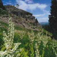
California Corn Lily: Be careful around this lovely, tall white flower. It is poisonous to both humans and honeybees. Watch for it in June and July along Kings Creek and Warner Valley.
Crimson Columbine: Watch for hummingbirds around these showy flowers. The yellow tip seems to sprout from five red petals. Native Americans boiled the leaves to make a sweet candy. This flower grows in rocky terrain around Dersch Meadows and Paradise Meadows in June and July.
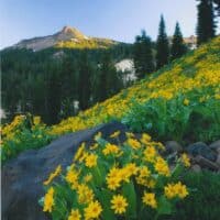
Mountain Mule Ears: The cheery yellow flower is a sunflower family member. The leaves of this flower are unique as they grow vertically as a method of retaining moisture. They are known to cover volcanic hillsides near Sulphur Works, Mill Creek Falls, and Butte Lake from June until August.
Applegate’s Indian Paintbrush: The dramatic red to yellow-red flowers are bordered by sticky, wavy-edged leaves. This flower is a parasite that attaches its roots to the roots of a host plant to get nutrients. Visit from June until August to find this flower on the forest floor around Sulphur Works and Manzanita Lake.
Western Wallflower: The flower is an essential food source for caterpillars and butterflies. It has also been used for its medicinal qualities. The name comes from a similar flower found in Europe that grows on walls. The bright orange-yellow flowers are visible along the main park road, especially near Sulphur Works, Summit Lake, and Twin Lake, from June until August.
Pussy Paws: Aptly named as it resembles the pink pads on a cat’s paws, this is an adorable flower. The plant gives the impression that it sleeps at night as the stem lowers the flower to the ground in the cool of the evening. The flower blooms from June until September and can be found on the rocky ground near Hat Lake, Mt. Harkness, and Warner Valley.
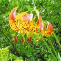
Leopard Lily: Resembling leopard skin, the flower features maroon spots on orange petals. This edible flower can be found in July and August along rivers and streams near Bluff Falls and Crumbaugh Lake.
Coyote Mint: Butterflies often flit around these pink, white, or purple clusters. People have used the leaves to make a calming tea. Look along the forest floors of Bumpass Hell, Hat Lake, and Prospect Peak from July until September.
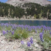
Silverleaf Lupine: This plant is recognizable by its purple flowers and silver tinting along the leaves. It can grow to heights of three to five feet. It likes to grow on gravelly ground on Mt. Harkness and in the Devastated Area from July until September.
Davis’ Knotweed: The small white flowers are held by triangular leaves that turn from green to red in the fall. This plant is especially suitable for surviving a drought. Look from them from July until September on the rocky ground near Lake Helen, Bumpass Hell, and Lassen Peak.
Before exploring wildflowers in Lassen, bring a camera or phone for pictures. Download the Wildflower Guide to help identify the many wildflowers you will see.
Other Areas Close By for Wildflower Viewing
Indian Valley/Taylorsville and Gennesse
Indian Valley is known for magnificent wildflowers near Stamfi Lane and North Valley Arm. The wildflowers can be seen from the road, making this a great area to view wildflowers via your car or bicycle.
There are many great hiking, biking, and fishing opportunities in the Indian Valley area. We recommend a stop in Taylorsville for a sandwich at Young’s Market to take with you. It is worth the 30-mile drive to visit Antelope Lake, a sparkling mountain lake at 5,000 feet. You will pass the Heart K Ranch, a great spot to stop and explore.
Indian Valley is also known for some great birding sites and Barn Quilts. Barn Quilt Map.
Roads Around Chester and Lake Almanor
Cruise around Chester and Lake Almanor, and it won’t be long before you are surrounded by blooming wildflowers. You’ll see bitterbrush, serviceberry, bush monkey, Indian paintbrush, California poppies, fawn lilies, purple camas, larkspur, yellow butterweed, and others. Pack a picnic and bring your fishing pole, just in case. If you’d like to take a drive to see some of the blooms, we recommend the following:
- Midway between Canyon Dam and Highway 36
- East shore of Lake Almanor along Highway 147
- Highway 32 just south of Chester
Big Springs
This is about 11 miles from Hwy 89 on the west side of Lake Almanor. Take Humbug Road (county road 309/307), about 10 miles across Humbug Valley. Left turn onto Forest Road. You’ll find a meadow that is fenced off to keep cattle out. You may duck through the fence to view the wildflowers: Sierra Crane Orchid, Sierra Corydalis, Douglas spiraea, and Giant Red Paintbrush. Since you are in the area, take time to visit Soda Springs. Yellow Creek is nearby and offers some good trout fishing.
Willow Lake Botanical Special Interest Area
Willow Lake is a designated Botanical Special Interest Area. Blooms are gorgeous from July until August. It is an easy drive north of Chester. Follow signs to Domingo Springs and, continue to forest road 29N114, turn right. This is about 4 miles of dirt road to Willow Lake.
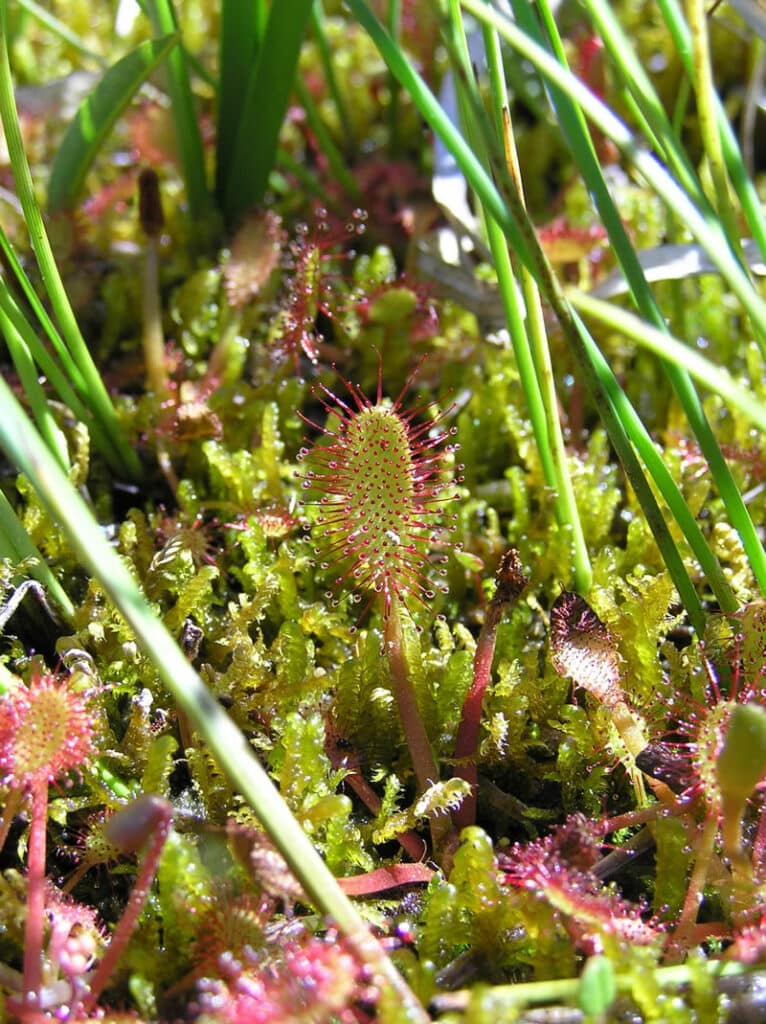
Willow Lake had mats of sphegnum mass two feet thick or more. You can walk on the mats and bounce on the top of the lake. The area is home to many unusual plants, many rare in California, such as American schechzeria, and two carnivorous plants, English Sundew and Round Leaf Sundew. From Willow Lake, it is a nice hike into Lassen National Park and Terminal Geyser.
Butterfly Valley Botanical Area
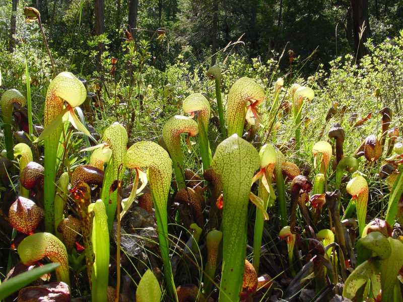
The Butterfly Valley Botanical Area, located just north of Quincy, reaches its color peak in June. Encompassing about 500 acres of stunning forests and meadows, this local treasure was designated as a botanical area in 1976 due to its rich diversity of plant life. It is home to 12 species of orchids, 24 species of plants in the Lily family, and nine species of ferns, poppy, buttercup, wild rose, and lady slipper. The Butterfly Valley Botanical Area is a great place to view the pitcher plant, a yellow plant that traps insects and digests them. The area gets its name from the butterfly shape when viewed from the sky.
Day Trip from Lake Almanor Area
Lost Creek in the Hat Creek Ranger District is another Wildflower Hotspot from April to May. It is a good spot for Arrrowlead Balsamroot, Applegatge’s Paintbrush, Spurred Lupine, Round Ookow, or Brodiaea.
To get here from Chester, take Hwy 36 East to Westwood. Left on A-21 ( or Mooney Road). Left turn on Hwy 44. Take a minute and stop at Hat Creek Rim Overlook. On a clear day, you can see the back of Lassen Peak, Mt. Shasta, and the valley you are headed two. This is a nice rest stop with clean bathrooms and mounted telescopes for viewing. Bring a few quarters. Continue on the 44 to 44/89 junction and turn right. You will pass the entrance to the Subway Caves, another fun stop. Continue onto Wilcox Road, turn right, and go about two miles to Forest Road 34N17. It is about three miles to the parking area. This is also an access area for fishing. Walk the trail upstream past the hydroelectric generating stations. From there, the base of Lost Creek Canyon is about one mile.
Feather River Scenic Byway
Take a drive down the Feather River Scenic Byway (Highway 70 through the Feather River Canyon), and you will be greeted with a breathtaking rainbow of color: the yellows of waterfall buttercups and monkeyflowers, the reds of the redbud shrub, the blues of silver lupine, and so much more. With its beautiful and diverse terrain, this route will also take you past cascading waterfalls, rugged canyons, and historic railways. You can access numerous hiking trails (including parts of the Pacific Crest Trail), campgrounds, and fishing holes from Feather River Canyon. Rafting and kayaking are also excellent during this time of year. Suggest driving the Feather River Scenic Byway to or from St. Bernard Lodge.