Hiking Trails on North side of Lassen National Park / Hwy 44
June 29, 2017 by: Sharon Roberts
Hike the best trails in and near the north part of Lassen Park, including Manzanita Lake, Spatter Cone, Subway Cave, Hat Creek Rim overlook and Cinder Cone.
This post covers the most popular trails in and near the northern section of Lassen Volcanic National Park. Manzanita Lake provides the first glimpse of the park for many visitors. Manzanita Lake is a favorite of many photographers, at the right time of day you can get a beautiful shot of the reflection of Lassen Peak on Manzanita Lake. For those interested in geology both Spatter Cone and Subway Cave just outside the park are very interesting hikes. Hat Creek Rim Overlook is a nice clean rest stop, one mile off of Hwy. 44. Great views of Mt. Shasta, Lassen Peak and the valley Burney Falls sits in can be seen from the overlook. Climbing to the top of Cinder Cone gives a bird’s-eye view of Fantastic Lava Beds and the Painted Dunes, along with more distant vistas of Lassen Peak and other major park summits.
Manzanita Lake and Lily Pond
Round-trip distance: 2.9 miles
High point: 5925 feet
Elevation gain: 100 feet
Season: June to October
Difficulty: 1 on a 1-5 scale
Contact: Lassen Volcanic National Park
Driving directions: Take the turnoff for the Manzanita Lake Campground, which is on the park highway 32.8 miles north of the junction of Highways 36 and 89, and 1.2 miles southeast of the junctions of Highways 44 and 89. Go 0.4 mile and then turn right to the picnic area and the trailhead.
Driving time from St. Bernard Lodge: 1.5 hours
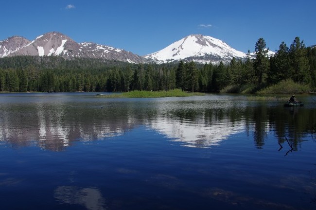
Manzanita Lake is one of the true icons of Lassen Volcanic National Park. Pictures of the lake, with Lassen Peak and Chaos Crags rising starkly beyond, are a staple of magazine articles about the park. This popular trail around the lake is easy and beautiful, and the Lily Pond nature trail is a logical extension of the excursion. Of course, Loomis Museum is also right there, allowing you to explore its many interesting exhibits.
Once you find the 1.8-mile-long trail, go left and begin circling the lake clockwise. Quickly leave the boat launch and developed areas behind and start enjoying the natural beauty. As it goes around the lake, the path occasionally enters a forest consisting of Jeffrey pine, sugar pine, lodgepole pine, and white fir, but much of the time you’ll be near the water, where black cottonwoods, willows, and mountain alder flourish.
The northwest edge of the lake has the best vista; this is where you’ll see Chaos Crags and Lassen Peak reflected in the lake’s surface, and it’s also an excellent spot to observe the ducks, geese, and the other birds that live here.
On the north shore 1.5 miles into the walk you’ll reach a trail fork. A right leads 0.3 mile back to the trailhead. Instead, go left to the parking lot at the Loomis Museum. Spend some time in the museum and then head across the park highway to the Lily Pond nature trail, where you’ll find the brochure that describes local natural history. The 0.9-mile loop goes clockwise, first along the shore of Reflection Lake and then to Lily Pond. When you’re done, return to the parking lot and beyond to the previous trail fork. Go left for the 0.3 mile level walk to the trailhead.
Spatter Cone
Round-trip distance: 1.7 - 2.1 mile loop trail
High point: 4,605 feet
Elevation gain: 141 feet
Season: April to October
difficulty: 1
Contact: Hat Creek Ranger District 530-336-5521
Driving Directions: Trail head is 1.5- 2.1 miles west of Hwy 44/89 Junction in Old Station on the south side of the Highway.
Driving time from St. Bernard Lodge: 1 hour 15 minutes
The Spattercone trail is an easy and interesting loop with 17 numbered stops corresponding to trail guide. Number 10, Steep Cone and number 11, collapsed pit which lets you look into a volcanic vent, are two favorite stops along the trail.
Just in case you wanted to claim that you have walked part of the Pacific Crest Trail you can do so on this loop.
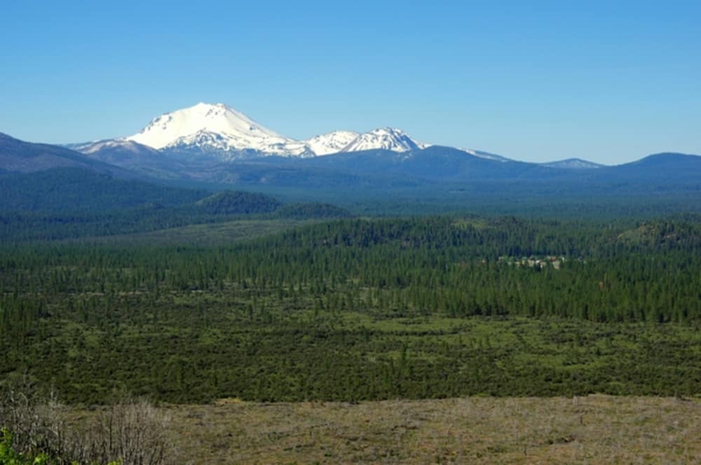
The area of Subway Cave and Spatter Cone is the second largest deposit of ancient lava in California. The trail is along the fissure of the Hat Creek Lava Flow. You will enjoy cones, craters and views of Badger Mountain, Raker Peak, Lassen Peak, Chaos Crags and Table Mountain.
This trail is best to hike early morning or late afternoon. This trail is dry and hot without shade cover.
Subway Cave
Round-trip distance: 0.6 mile
High point: 4350 feet
Elevation gain: 50 feet
Season: April to November
Difficulty: 2 on a 1-5 scale
Contact: Hat Creek Ranger District, Lassen National Forest
Driving directions: Find the Subway Cave access road on the east side of Highway 89 about 0.3 mile north of the junction of Highways 89 and 44 East (across from Cave Campground) and go 0.2 mile to the parking area.
Driving time from St. Bernard Lodge: 1 hour
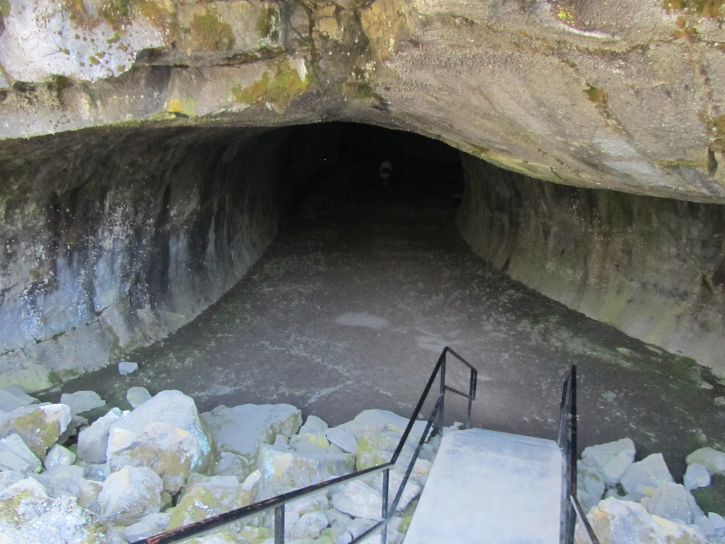
Subway Cave is one of the best examples of a lava tube in Northern California. You’ll walk 1300 feet through the cave, with the option to either return the way you came or take two different trails. You must follow all posted rules for entering the cave. In addition, bring warm clothes (it’s cold in there, even in summer) and bring at least two flashlights or headlamps per person. Also watch your head, especially if you’re tall.
Descend the steps to enter the cave. Numerous lighted signs explain how the cave formed and other interesting aspects of natural history. As you progress, you’ll pass features with intriguing names like Stubtoe Hall and Lucifer’s Cul-de-Sac.
Come out of the cave’s southeast end at Rattlesnake Collapse. You now have three options. First, you can return back through the cave. Second, you can take the trail to the right that travels above the cave to the cave entrance. Third, you can take the slightly longer path to the left that loops clockwise back to the parking area. Both the aboveground options give good views of surrounding mountains, including the Hat Creek Rim to the east.
Cinder Cone, Painted Dunes, and Snag Lake
Round-trip distance: 8.2 miles
High point: 6907 feet
Elevation gain: 1000 feet
Season: July to October
Difficulty: 4 on a 1-5 scale
Contact: Lassen Volcanic National Park
Driving directions: From Highway 36 in Westwood, take Mooney Road (County Road A21). Go 18 miles to Highway 44 and go left. Continue 17 miles and then turn left (south) onto Forest Road 32N21. Drive 6.0 miles to Butte Lake Campground and park near the boat launch area.
Driving time from St. Bernard Lodge: 1.5 hours
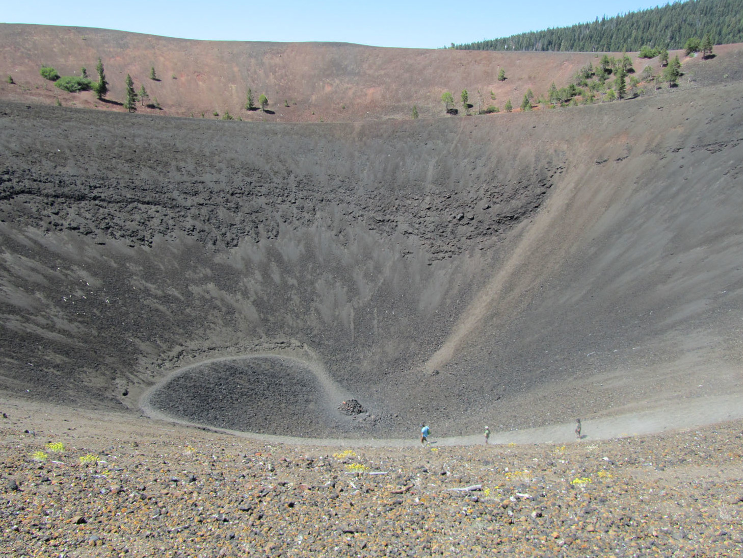
Cinder Cone is the prime destination for this hike. After the ascent of its steep flanks, you’ll have broad views over much of the park, including the strikingly colored Painted Dunes just below. Most people head back from the summit, but if you have the time and energy, continue on to Snag Lake. Note that this is not a good hike on a hot day: it’s exposed to the sun and the ground reflects and radiates a lot of heat. Make sure to bring plenty of water and a good hat.
At the trailhead, take the brochure for the nature trail portion of the initial part of the hike; it describes important details of local and natural history, including the fact that you’re walking on the Nobles Emigrant Trail, a route to California for emigrants in the 1850s and 1860s.
Walk beside the edge of basaltic Fantastic Lava Beds and stay to the left at 0.4 mile when a trail heads right to Prospect Peak. Stroll another 0.9 mile to another fork just below Cinder Cone. The longer version of this hike will bring you back by the right-hand path, but now you have to grunt your way up to the top of Cinder Cone, which is not an easy undertaking: just take it one step at a time for the entire 750-foot elevation gain and always stay on the official trail.
The views from the 6907-foot summit make all the effort worthwhile. You’ll see all the major peaks in the park, including Prospect Peak, Chaos Crags, Lassen Peak, Brokeoff Mountain, Mount Conard, Reading Peak, and Mount Harkness. Just below are the Fantastic Lava Beds and the Painted Dunes, along with Butte Lake and Snag Lake.
For the longer journey, continue down the south (far) side of Cinder Cone. Go left at 2 trail forks that are close together (a right at either one will lead you to the north side of Cinder Cone and back to the trailhead), and then left again at a third fork that’s 0.4 mile south. From here it’s a 1.5-mile southeasterly hoof next to Fantastic Lava Beds and the Painted Dunes to the northwest corner of Snag Lake, where you’ll find good spots to sit and gaze at the lake and surrounding forested mountains.
When you’re ready to return, head back the way you came toward Cinder Cone, going right at the first trail fork and then left at either of the next two trail forks, both of which quickly bring you to the Nobles Emigrant Trail, where you go right for the final 1.9 miles to the trailhead at Butte Lake.